
Surveying the aqueducts in the Nasca region in southern Peru
Aim of the project
The aqueducts in the Nasca region are among the oldest irrigation systems in the Andean world. They have their origin in the Paracas (approx. 800 - 200 BC) and the subsequent Nasca culture (approx. 200 BC - 650 AD). They represent a widespread, sophisticated irrigation system that still brings water from subterranean springs to one of the driest areas in the world and thus represented the livelihood of many people in this region for thousands of years. The water systems generally consist of underground channels, some of which are open and some of which are closed. The latter are often accessible via so-called puquios (spiral entrances).
Some of the aqueducts are still used today, especially for agriculture. Only one complex by Puquios in Cantalloc east of Nasca has been almost completely restored and opened up for tourism. Many of the almost 40 facilities are neglected as a result of disorderly urban growth - especially in the greater Nasca area. Therefore, the potential of the aqueducts for recognition as a World Heritage Site is to be evaluated as part of an interdisciplinary project. As a basis for this, all aqueducts and puquios must first be surveyed, analyzed with regard to their current condition and documented cartographically.
Content
A field campaign took place in September 2016 in which Prof. Dr. Bernd Teichert and MSc (GIS) Christiane Richter from the HTW Dresden and Prof. Dr. Karel Pavelka from the TU Prague took part. On the Peruvian side, the project was supported by the Mayor of Nasca, Prof. Eusebio Alfonso Canales Verde, and the staff of the Agencia Agraria (Agriculture Authority) and the Autoridad Nacional del Agua (National Water Authority) in Nasca. The mayor of Nasca also provided an 4x4 vehicle and additional staff.
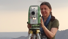
During this measurement campaign, a total of 34 aqueducts in the Nasca and Taruga areas were surveyed using GPS. Both Garmin receivers and Leica Viva Uno GNNS handhelds were used. All GPS measurements were evaluated directly on site.

As part of the 2016 measurement campaign, some selected aqueducts were photogrammetrically recorded using UAV (Unmanned Aerial Vehicle, also known as drones). The main problem was that most of the aqueducts are not visible from the air, or only to a limited extent, because they are either overgrown by plants or serve as rubbish dumps. Initially, therefore, only five installations were suitable for aerial surveys, namely the Cantalloc, Orcona and La Gobernadora aqueducts in the Nasca Valley and San Carlos and Santa Maria in the Taruga Valley.
The drone used by the TU Prague was an eBee UAV (sensFly SA/Switzerland). In addition, two different digital cameras were used during the flight, a Canon ELPH110HS and a Canon IXUS, each with 16.1 Mpix. For exact georeferencing, 4-5 control points were additionally determined using DGPS (Differential Global Positioning System).
The evaluation of the measurements was carried out both at the TU Prague and at the HTW Dresden using the software Agisoft PhotoScan. The results were orthophotomosaics and digital terrain models of the five aqueducts.

All aqueducts were recorded on the basis of the existing high-resolution image data from the Quickbird satellite (geometric resolution: 0.6 m) and GPS measurements and entered into the database of the NascaGIS geographic information system. In addition to topographical data (e.g. roads, rivers, towns, buildings and types of use), the NascaGIS contains all archaeologically relevant data (lines and figures in the pampas, archaeological excavation sites etc.) in the Nasca/Palpa region. Both the geometry and all relevant attribute data (such as names, condition, size specifications and other information on the individual objects) are saved.
Based on the NascaGIS data, a topographic map of the aqueducts in the Nasca Valley was created in spring 2017 as part of a bachelor thesis at the HTW Dresden.

Project team

Project partner
The project is carried out in cooperation with the Laboratory for Photogrammetry at the TU Prague, represented by Prof. Dr.-Ing. Karel Pavelka performed.
On the Peruvian side, the project was supported by:
- the Asociación María Reiche in Lima
- the Mayor of Nasca Prof. Eusebio Alfonso Canales Verde,
- the staff of the Agencia Agraria (Agriculture Agency) in Nasca,
- the Autoridad Nacional del Agua (National Water Authority) in Nasca.
The project received technical support from Leica Geosystems Germany.
Galery


