
Lines and Figures at the Pampa of Nasca/Peru
Aim of the Project
One of the most fascinating and so far unsolved mysteries in human history is hidden in the "Pampa of Nasca" in southern Peru. Several hundred square kilometers of rock-strewn desert are covered with thousands of lines, large biomorphic figures and various geometric shapes. These so-called geoglyphs represent an artistry of a special kind, neither carved nor painted. They were caused by removing the darker, oxidized layer of the desert’s surface to expose the lighter, unoxidized sub-soil below. But the geoglyphs certainly did not arise all at once; many of them overlap, the oldest drawings are almost invisible. Most of these drawings have their seeds in the pre-Columbian Nasca culture (approx. 200 BC – 650 AC). Because of the dry and stable climate, the light-colored traces have remained nearly unchanged during the last 2000 years. But today this world cultural heritage is threatened with destruction as a result of climate influences, environmental pollution and mass tourism.
The Dresden born researcher Dr. Maria Reiche was the first one who fought against the destruction of the Nasca Lines. It’s not possible to enumerate all her efforts and activities. Not least because of her engagement the lines where added to the UNESCO World Heritage List in February 1995. In memoriam of Maria Reiche and in order to help to protect and preserve the cultural heritage of Nasca and Palpa a scientific project was originated at the Faculty of Spatial Information in 1995. One of the main objectives of this Nasca project is the digital conservation of the lines and figures of Nasca and Palpa. Therefore, the development of a geographic information system (NascaGIS), in which all available data on the soil drawings are stored, managed, analyzed and presented, is in the foreground. A WebGIS application gives all interested parties access to the results of the project.
To this day, there are numerous theories surrounding the mystery of the origin and meaning of the Nasca lines and figures. Maria Reiche dealt with this question for more than 40 years. She suspected that the Nasca Indians used the drawings as a kind of calendar. Investigating this theory and thus continuing the work of Maria Reiche is another important focus of the research project.
Content
The heart of the research project is the NascaGIS. The data model for the NascaGIS, which is implemented in an Oracle database, was created as part of several diploma theses at the Faculty of Spatial Information. Here all data and information about the geoglyphs in the Pampa are recorded, managed, analyzed and prepared for the presentation.
All the results are available in a NascaGIS application on the Internet.

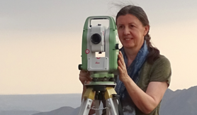
In order to be able to obtain the geoglyphs in digital form, they must first be recorded geometrically. In view of the size and limited accessibility of the area, classic measurement methods for vector data acquisition are not useful. A more effective method is the photogrammetric evaluation of aerial and satellite images. However, this requires georeferencing of the images. The control points required for this were determined on site using GPS methods. A total of five GPS measurement campaigns have been dedicated to this goal so far. All campaigns were technically supported by Leica Geosystems (in Peru: Química Suiza).
The entire control point measurement is based on a fixed point field created in 2004, which was attached to the permanent GPS stations in Lima and Arequipa/Peru, Bogota/Colombia and Santiago de Chile. Based on this fixed point field, about 2.500 ground control points could be determined in the field over the years using DGPS (Differential Global Positioning System).

The most important basis for every GIS is the data. 179 photogrammetric aerial photos from the year 1998 and very high-resolution satellite images (Ikonos, Quickbird, WorldView and GeoEye) served as the basis for the data acquisition.
The images were georeferenced using control points determined during several GPS measurement campaigns. These georeferenced aerial and satellite images served as the basis for digitizing the ground drawings and all topographical objects in the pampas. The images are also used to produce aerial and satellite maps.

The astronomical thesis is one of the many theories about the origin and original meaning of the geoglyphs in the pampas of Nasca and Palpa. She assumes that long lines and areas in the pampas were aligned with selected celestial bodies (sun, moon, planets and/or very bright stars) in the Nasca period. The drawings in the desert could thus have served to determine times for sowing and harvesting, for example. In addition, the figures in the pampas could have corresponded to the constellations of the Nasca people.
In several theses at the Faculty of Spatial Information, software programs were created that make it possible to calculate correlations between lines and areas in the pampas and positions of stars, planets, sun and moon during the Nasca period. With the help of these programs, it was initially possible to verify some of Maria Reiche's observations. Here there was a very good agreement of lines with bright stars and the sun. In general, however, one can say that not all soil drawings can be explained with astronomy.

An important basis for checking the astronomical theory is a very accurate digital terrain model (DTM) of the entire area, in order to be able to calculate the exact position of the rise and set of the stars. In addition, a DTM can be used to create 3D visualizations and animations.
For example, stereo image data can be used to create digital terrain models. In this way, digital terrain models of different resolutions were created from the stereo models of the photogammetric aerial photographs and from the stereo satellite image data (Aster). Data from the Shuttle Radar Topography Mission (SRTM) was also used for some tasks.

In addition to recording the geoglyphs, another task of the project was the recording of rock drawings (so-called petroglyphs). Strictly speaking, these are not drawings, but rock carvings. About 150 such petroglyphs have been documented and photogrammetrically recorded over the years. Most of these petroglyphs are found in the valleys surrounding the city of Palpa.
")
In addition to the geoglyphs and petroglyphs in the pampas, historically valuable buildings in the region around Nasca and Palpa are also photogrammetrically recorded. There is a close cooperation with the Laboratory of Photogrammetry at the TU Prague. Some buildings were evaluated there as part of project and final work and made available as 3D buildings in Google Earth.

The production of topographic and image maps is another task of the project. About twenty diploma, bachelor and master theses have been dedicated to the creation of maps over the years. In addition to topographic maps, above all orthophoto and satellite image maps were created in various scales.
The first satellite map of the Nasca pampas was presented in Peru in the summer of 2004 and aroused great media interest there.

Project team

Project partner
Since 2003 there has been a close cooperation with the laboratory for photogrammetry at the TU Prague, represented by Prof. Dr.-Ing. Karel Pavelka.
The project has also been supported for many years by:
- "Dr. Maria Reiche - Lines and Figures of the Nasca Culture in Peru" e.V. Dresden
- Association "Maria Reiche" Lima/Peru
- Leica Geosystems GmbH Germany
- Química Suiza Lima/Peru (Leica representative in Peru)
Picture gallery


