Computer and Geoscience in Archaeology: Projects and Theses
Research and teaching are one. Concrete projects play an important role in the development of the Computer and Geoscience in Archaeology program. With our national and international partners we work on the development and application of solutions for archaeology. Modern technologies open up new ways of data acquisition, analysis, presentation and communication of knowledge related to archaeology and the cultural heritage of mankind. The work of team members engaged in teaching, research and study on the projects contributes directly to the development of the curriculum.
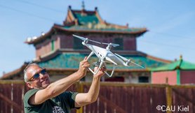
Within the projects archaeocopter and archaeonautic, under the supervision of Prof. Dr. Marco Block-Berlitz solutions for the efficient and cost-effective recording of digital 3D data are developed. Platforms for the recording and of image and video data on the ground, from the air and under water are being developed and tested. Furthermore, software solutions for the image-based reconstruction of 3D-models are being developed, enhanced and applied in collaboration with many different partners from the field of archaeology.
Webpage of the project Archaeocopter / Archaeonautic
Together with instructors and students of the HTW Dresden , Dr Hendrik Rohland works on projects for the application of technologies (GIS, remote sensing, VR/AR etc.) in the research and valorisation of archaeological monuments. His main field of work are the medieval city complexes and their surroundings in Mongolia. In addition to his work at the HTW, he is a research assistant for the project "Cultural Landscape of the Orkhon Valley" at the German Archaeological Institute (DAI), where, in addition to archaeological research, he is primarily concerned with the topics of research data management, geoinformation systems and remote sensing.
To the DAI project Cultural Landscape of the Orkhon Valley
The Faculty of Spatial Information also works in the field of archaeological-historical research. Prof. Dr. Martin Oczipka is working in cooperation with Mongolian and German partners on research into abandoned city sites of the early modern period in present-day Mongolia.
The Virtual Museum of the Orkhon Valley
Since 2018, students and lecturers from the HTW Dresden have been involved in the Mongolian-German Expedition to Mongolia. Now, Dr Hendrik Rohland, visiting professor of archaeoinformatics, has been supporting the development of a virtual museum that presents the results of more than 20 years of Mongolian-German archaeological research. The results of excursions by students from the HTW Dresden to Mongolia have also been incorporated into the museum.
For more than 20 years, the Mongolian Academy of Sciences, the National University of Ulaanbaatar and the German Archaeological Institute have been conducting joint research on archaeology and history in Mongolia. The investigations focus on the two medieval city complexes of Karabalgasun from the 8th/9th century and the old Mongolian capital Karakorum from the 13th/14th century in the valley of the Orkhon river. Since 2018, the HTW Dresden has also been involved in the project, for example with the ‘ArchaeoCopter’ project (Prof. Block-Berlitz) and the use of georadar (Prof. Oczipka). As part of the Future.East project (2020-2023), there was an intensive exchange with the National University of Mongolia (NUM). This programme also included excursions by students from Dresden to Mongolia and from Mongolia to Dresden. The central topic was ‘archaeoinformatics’, i.e. the application of techniques and methods from computer science and geoinformation in archaeology.
In order to present the results of many years of research to the public independently of a visit to the site, a web portal was developed as the ‘Digital Museum of the Orkhon Valley’ to mark the 50th anniversary of diplomatic relations between the Federal Republic of Germany and Mongolia. In this digital museum, a multimedia approach and a trilingual version (Mongolian/German/English) are used to create various access points to the history and archaeology of the region. In this way, the scientific findings that have been developed over many years are made publicly available in a generally understandable language and appealing design. The conception and development was supported by the Visiting Professorship for Archaeoinformatics (Dr Hendrik Rohland) at the HTW Dresden. Thus, the results of the work of HTW Dresden students on excursions to Mongolia were also incorporated into the development of the content.
In addition to communicating archaeological results, the virtual museum will in future provide a platform for presenting new projects and results related to the Orkhon Valley World Heritage Site, including, for example, future projects by students and researchers at the HTW Dresden. The development was financed by the German Federal Foreign Office and the Mongolian Ministry of Culture, Sports, Tourism and Youth.
The Orkhon Valley Virtual Museum can now be explored here:


Theses
The active research and development work is also reflected in the teaching. Students are involved in the projects and some take the opportunity to write their theses in the exciting field of applied computer science in archaeology.
2020/2021
Semi-autonomous classification of archaeological structures
Master's thesis
Huy Do Duc
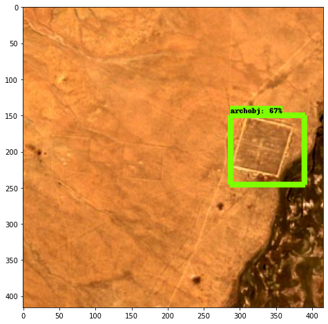
This work dealt with the exploration of archaeological sites using machine learning and satellite imagery from all over Mongolia. For this purpose, free data was acquired from Senitel-2 satellites. In addition to the satellite images, information from about 100 already documented archaeological city and rampart sites was used. On this basis, the training data could be created. The satellite images had to be processed and adapted for the machine learning model. Multispectral information was also used. False colour images were generated and index calculations were carried out. By altering the colour information, stronger contrasts were to be generated, which could enable better recognition of archaeological features. The Faster-R-CNN model was tested with the self-generated dataset. Unfortunately, the results of the training are not good enough, as the accuracy in the recognition of archaeological objects is insufficient. The likely reasons for this are the small amount of training data available and the insufficient resolution of 10 m per pixel. Many of the known archaeological objects in Mongolia are relatively small and thus not usable under the methods described in this paper.
Augmented Reality as support and enrichment for museum exhibitions
Bachelor's thesis
Lukas Suthe
Museums are subject to constant reinvention and have to adapt to an ever faster changing information society and its demands for entertainment and interactivity. To meet these challenges, a digital transformation with new concepts and technologies is necessary so that people's interest in knowledge is maintained in the future.
Augmented reality (AR) describes the enhancement of the real environment with virtual content registered in space in real time and makes it possible to create a degree of immersion in the user where he or she can hardly distinguish between real and virtual parts. This, and the fact that AR is now available almost everywhere and to everyone via smartphones due to a rapid development of software and hardware, opens up countless possibilities for many areas, including museums.
As part of a bachelor's thesis in the Media Informatics program, the use of augmented reality in museums and the associated requirements regarding technology, curation needs and user experience to implement a satisfactory application have been examined. It was further examined how augmented reality can be used, among other things, as a means of digital transformation by museums to inform visitors according to their increased demands regarding entertainment and interactivity. As an example of this, different possible AR use cases at the Kharakhorum Museum in the UNESCO World Heritage Site Orkhon Valley in Mongolia have been analyzed and experimentally implemented based on the research results. A basic concept as well as a prototype of an AR application for museum visitors was developed.

Procedural 3D reconstruction of historical architecture in archaeology
Dominik Klenk
Bachelor's thesis
The project with the topic "Procedural 3D reconstruction of historical architecture in archaeology" had the goal to realize a 3D reconstruction of the "Great Hall" of Karakorum in Mongolia. With the help of a script the procedural construction of several different reconstruction variants is to be made possible. The goal was to create a 3D model of a temple based on the user's input by means of various modifiable parameters. Possible variations are, for example, the number of columns, the respective yokes or distances between the columns, as well as the number of floors. Since there is not much data available on the height of the Great Hall of Karakorum or the construction techniques used, the representation of the temple is based on a combination of the available archaeological data, information from an ancient inscription describing the temple and a medieval Chinese construction manual. With the help of this building manual, dependencies and proportions of the different components can be determined and thus help to approximate the historical architecture. In addition, the model of the temple should be able to be displayed in various degrees of detail, for example, to enable a representation in AR apps or films. The project is implemented with the help of the open-source program "Blender". Within Blender, scripts for the generation of models can be created with the help of the programming language "Python". Also the realization of a UI for easy operation and creation of the temples can be implemented in this environment. As a result, it becomes possible to implement different variations of historical architectures in a very short time and thus create models with little effort, which can be used for further investigation of various theories and applications for knowledge mediation.

2020
Segmentation of digital elevation models for the identification of archaeological building forms
Diploma thesis
Huy Do Duc
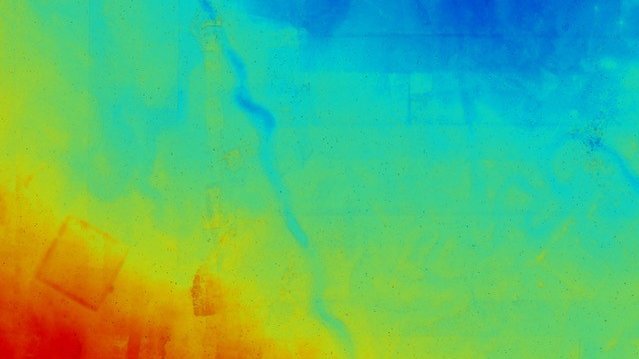
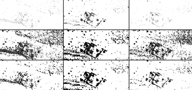
For the identification, exploration, and monitoring of archaeological traces of the past in today's landscape, digital terrain models are an important resource. Using a semi-automatic approach, a processing pipeline for such geospatial data was presented, with a focus on segmentation to identify archaeological structures. A QGIS plugin was also developed to find areas of interest in large datasets more quickly, and to enhance their visibility.
For digital elevation models, there are a number of visualization techniques (Hillshading,
Openness, Sky-View-Factor, Trend-Removal). In order to apply these techniques correctly, their results were compared. The goal was to find out which technique is suitable for which landscape. For a simpler interpretation, visualizations from remote sensing and methods from computer science were used together to improve the visibility of landscape features.